
scoobert
Has Left the Room - Banned from VTCOA!
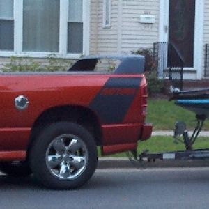
nosed up to it to get under as much as i could.05QCSRT10 said:Did you seriously drive right into that thing?
who got nominated for totm?
and now last night.
about 2am i woke up shivering. the power was out. was out for 8 hours.
so i plowed.
earlier in the day i plowed 6" of snow.
when i walked out it was up to my knees. and i'm 5'11".....
took me an hour to do the driveway.
cop was on the road because a tree was down on the powerlines. after about 30 min she was fast asleep. the county worker had to wake her up after he trimmed the tree.
i think there is another 8" out there now. not sure i want to go out.
i need to do the driveway again, and then do the little old mans driveway. i am not sure how i will with 24 or so inches on the ground.
now this:
TOTAL SNOWFALL ACCUMULATIONS OF GENERALLY 8 TO 16 INCHES ARE EXPECTED BY THE TIME THE STEADY SNOW TAPERS OFF TO SNOW SHOWERS EARLY THIS EVENING. HIGHER AMOUNTS OF 10 TO 20 INCHES ARE EXPECTED ACROSS THE EASTERN CATSKILLS... HELDERBERGS AND SCHOHARIE COUNTY.
SINCE THE SNOW IS HEAVY AND WET... THE WEIGHT OF THE SNOW WILL LEAD TO SOME DOWNED LIMBS AND POSSIBLY TREES AND POWERLINES... RESULTING IN SCATTERED TO NUMEROUS POWER OUTAGES.
THE HEAVY WET SNOWFALL WILL BE THE RESULT OF LOW PRESSURE OFF THE MID ATLANTIC COAST... WHICH WILL MOVE NORTHWARD TO SOUTHERN NEW ENGLAND THIS AFTERNOON.
A SECOND... AND PERHAPS MORE POWERFUL STORM... IS EXPECTED TO IMPACT THE REGION FROM LATE WEDNESDAY NIGHT... THROUGH THURSDAY... AND INTO FRIDAY. A PERIOD OF HEAVY SNOWFALL IS POSSIBLE ON THURSDAY AND THURSDAY NIGHT... AS A STORM CENTER INTENSIFIES NEAR NEW YORK CITY. STORM TOTALS OF A FOOT OR MORE ARE POSSIBLE.